

Assessment of the impact of human activities on the soils of the Șureanu Mountains
Project code: PN 23-39-04-02 PN-23-39-04-02.pdf
Project Manager: Dr. Monica Ghenciu
Description
The project aims to evaluate and quantify the effects of human activities on mountain soils in the Șureanu Mountains area. Deforestation, intensive grazing, and tourism involving off-road vehicles, motorcycles, and ATVs are among the activities that lead to soil degradation. Of these, massive deforestation poses a major threat, and Romania is one of the countries with a very high rate of deforestation in mountain areas. Massive deforestation causes both chemical soil degradation (qualitative degradation) and soil degradation through erosion (quantitative degradation).
Within the framework of the project, we aim to address the impact of human activities on soils using an interdisciplinary approach, realized through the creation of various types of maps. These maps will provide information on the distribution of forested areas, deforested areas, and pastures; soil quality (chemical composition and thickness); and the petrographic nature of the geological substrate (which supplies the soil’s mineral component) and its influence.
Based on the obtained maps, we will create an integrated cartographic model of vegetation distribution, soil thickness, geochemistry, and the influence of the geological substrate; this model will highlight areas in the Șureanu Mountains where soils are degraded in terms of quality and/or quantity. This model represents a specific technology for assessing the impact of human activities on soils and can serve to monitor soil conditions, helping to identify solutions for biodiversity conservation and resilience in the face of climate change.
Objectives
Within the framework of the project, we aim to achieve the following objectives for identifying areas with degraded soils and erosion risk:
- Creation of a map showing the distribution of forested areas, deforested areas, and alpine pastures in the Șureanu Mountains;
- Creation of the geological map of the Șureanu Mountains, featuring lithological and structural details relevant to soil geochemistry;
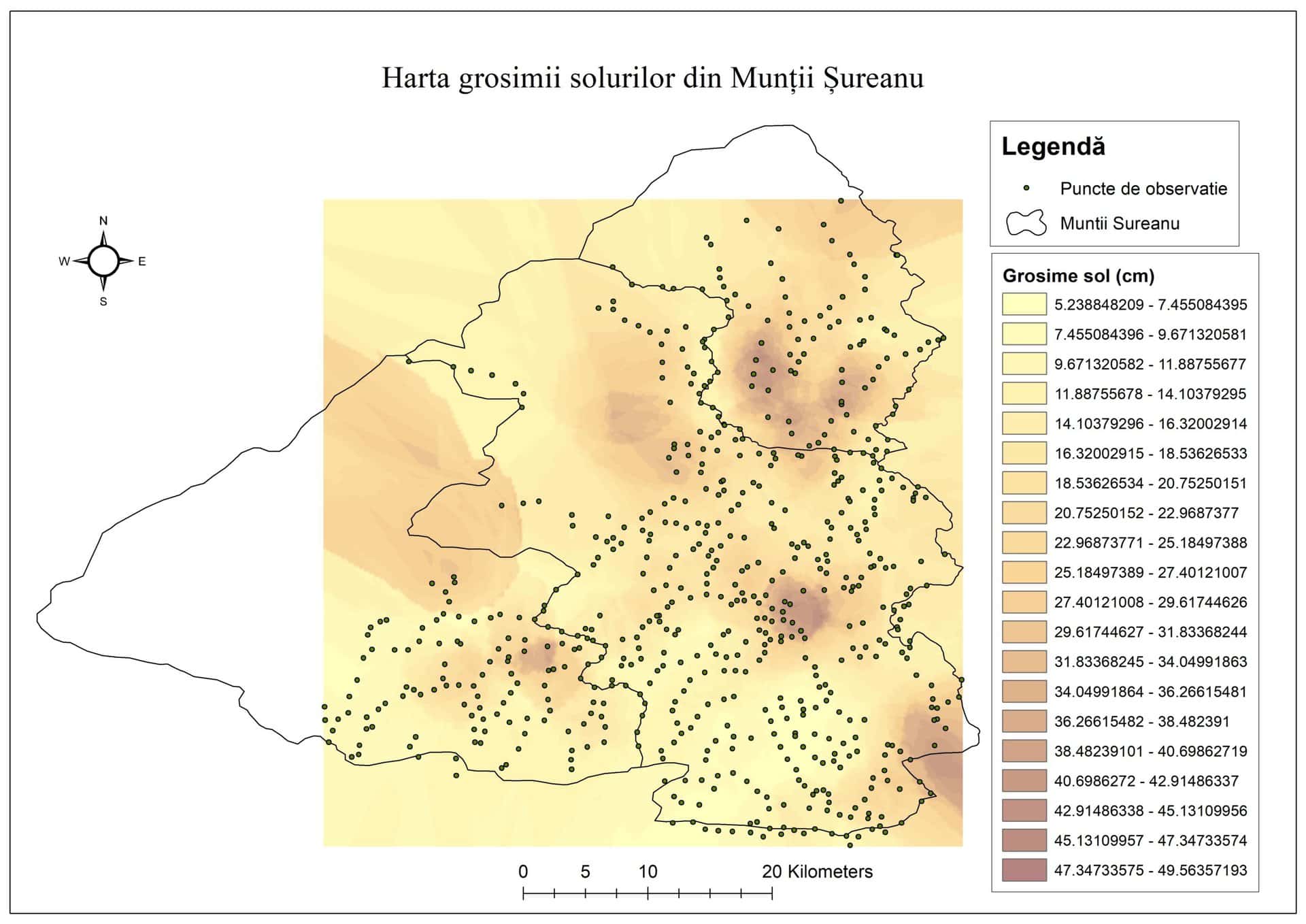
- Creation of a soil thickness map for the Șureanu Mountains, highlighting areas at risk of erosion;
- Creation of a geochemical soil map of the Șureanu Mountains, highlighting soil quality and the influence of the geological substrate upon it;
- Development of an integrated cartographic model mapping the distribution of vegetation, soil thickness, geochemistry, and the influence of the geological substrate—a model highlighting areas in the Șureanu Mountains with soils suffering from qualitative (chemical) and/or quantitative (erosion) degradation. This integrated model enables an assessment of the current situation and can serve as a basis for future soil quality monitoring; it can also be applied to other mountain areas affected by destructive human activities.
Result
- Map showing the distribution of forested areas, deforested areas, and alpine pastures in the Șureanu Mountains;
- Geological map of the Șureanu Mountains;
- Map of soil thickness in the Șureanu Mountains;
- Geochemical map of the soils in the Șureanu Mountains;
- Integrated cartographic model of vegetation distribution, soil thickness, geochemistry, and the influence of the geological substrate.
The first step toward achieving the objectives was defining the study area and creating the database. The area selected for the database corresponds to the 1:200,000 scale map sheet L-34-XXIV (Orăștie sheet), which encompasses the Șureanu Mountains at its center. The inclusion of a sufficiently wide data buffer zone around the Șureanu Mountains facilitates subsequent analyses of the datasets and the interpolations required for soil erosion modeling.
The database was created as a geodatabase file (with the gdb extension) using ArcGIS and comprises vector data—featuring point, line, or polygon geometries—grouped by thematic category into Feature Datasets, as well as raster data (images or grids), with some grouped into a raster catalog (geophysics) or a raster mosaic (orthophotos).
The following have been entered into this database:
- Datasets extracted (clipped to the L-34-XXIV map sheet boundary) from existing IGR datasets compiled over time, reprojected (where applicable) to the Stereo 70 projection, and with the legend updated to reflect the categories present within the sheet.
- Datasets downloaded from the internet were used to create a Digital Elevation Model (DEM) and—utilizing tools from the ArcGIS 3D Analysis module—to generate new maps: a hillshade map, a contour map, a slope aspect map (indicating slope orientation: N, NE, E, SE, S, SW, W, NW), and a slope gradient map (expressed in degrees or percentages).
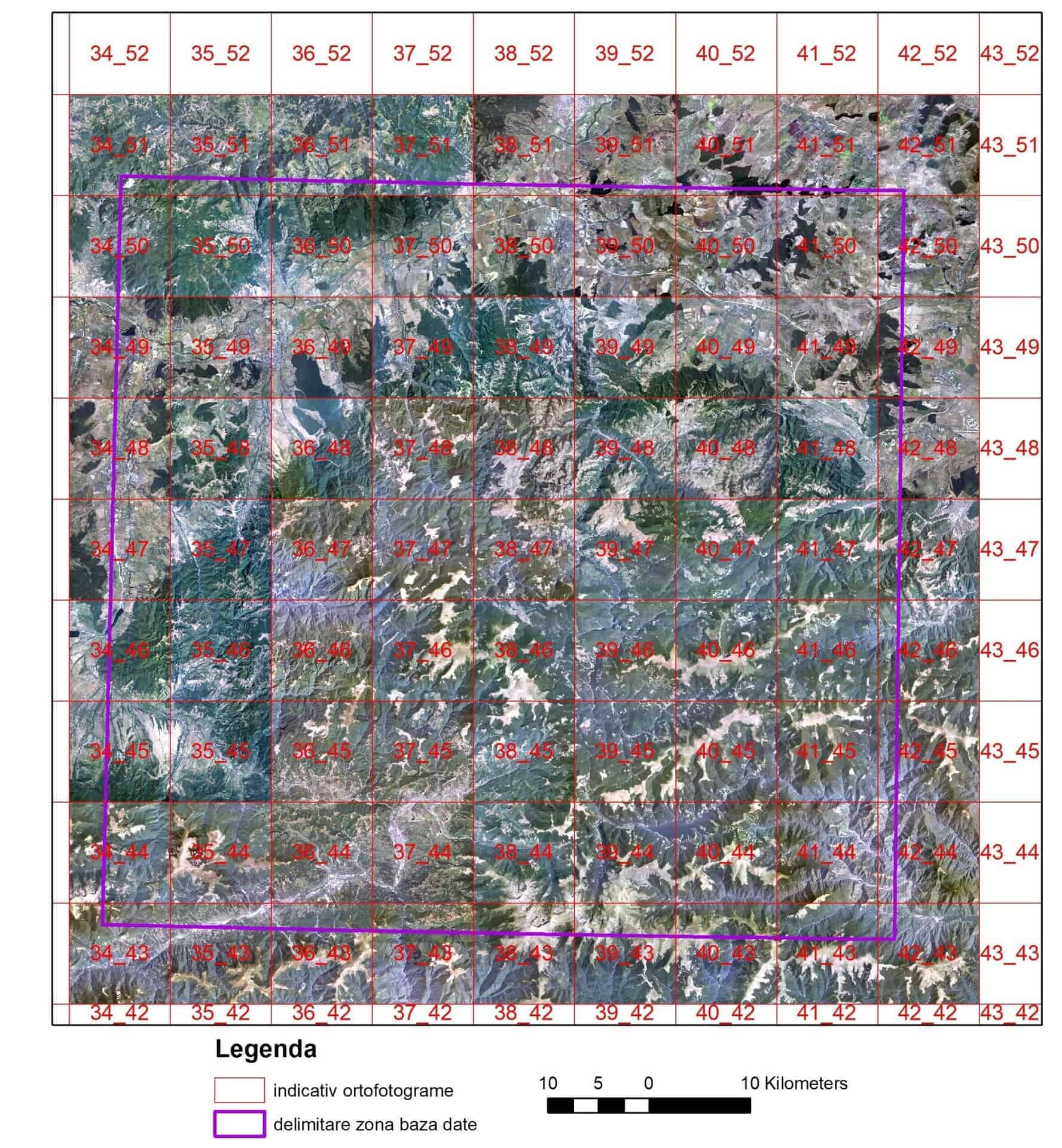
- Orthophotos (Fig. 1), totaling 81 digital images in tif format—each covering a 10 km x 10 km area with a pixel size of 0.5 m—recorded in the visible range of the electromagnetic spectrum between 2005 and 2009 by the Military Topographic Directorate.
- The current soil map of Romania for the Orăștie sheet, produced by the Research and Development Institute for Soil Science, Agrochemistry and Environmental Protection (ICPA) Bucharest.
Fig. 1 - Orthophoto mosaic in the visible range of the electromagnetic spectrum - sheet L-34-XXIV Orăștie
The developed database also integrates data on SCIs (Sites of Community Importance – Habitats Directive 92/43/EEC of 1992) and SPAs (Special Protection Areas for avifauna – Birds Directive 79/409/EEC of 1972), as well as polygons outlining nature reserves and areas of special interest within the Grădiștea region.
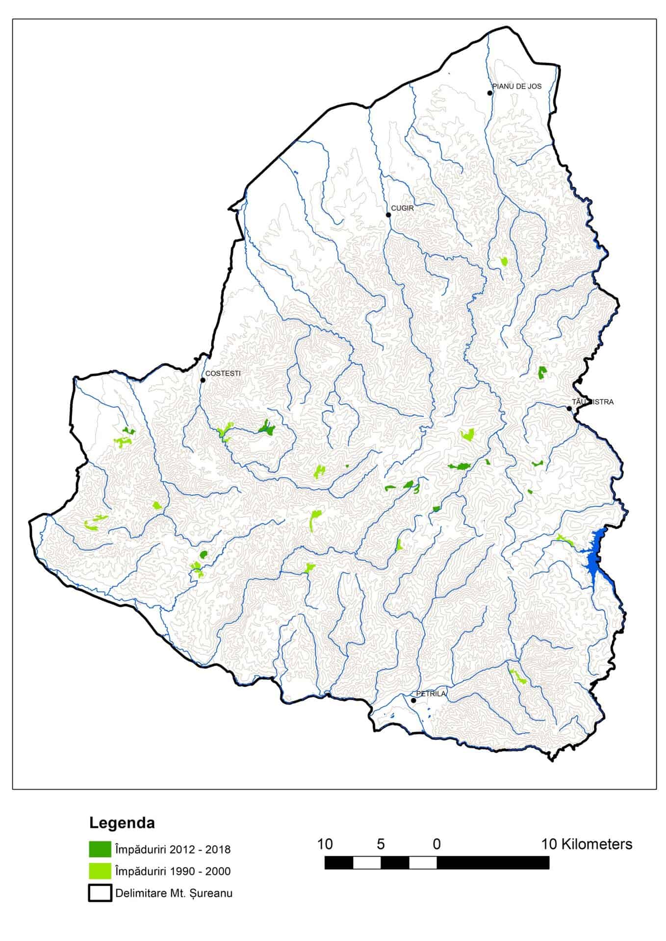
To assess areas where forest changes occurred due to deforestation and to estimate the ratio of cleared areas to afforested areas, Land Cover change datasets (in file geodatabase format) were downloaded from the Copernicus website for the following periods: 1990–2000, 2000–2006, 2006–2012, and 2012–2018. These datasets were reprojected to the Romania Double Stereographic (Stereo 70) coordinate system and then clipped to the boundary of the Șureanu Mountains. Data were extracted from the attribute tables regarding areas previously covered by deciduous, coniferous, and mixed forests that had transitioned to the “tree–shrub transition zone” category, corresponding to deforested areas. Similarly, classes corresponding to forest codes in the newer imagery—representing afforested areas—were extracted. The distribution of deforested areas is shown in the map in Fig. 2, while the distribution of afforested areas is shown in Fig. 3.
Fig. 2 - Map showing the distribution of deforested areas in the Șureanu Mountains
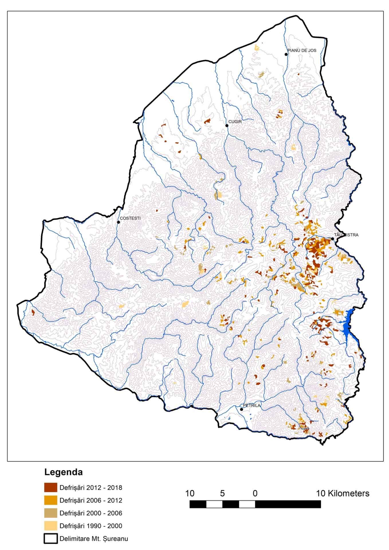
Fig. 3 - Map showing the distribution of forested areas in the Șureanu Mountains
Field geological research contributed to the creation of a partial geological map of the Șureanu Mountains (Fig. 4). From a lithostructural perspective, the metamorphic rock sequence in the Șureanu Mountains—spanning an exposed thickness of approximately 2,000 m—consists of four petrographic complexes. In vertical succession, from bottom to top, these are: a) the augen gneiss complex, b) the micaceous gneiss complex, c) the quartz-feldspathic gneiss complex, and d) the mica schist complex. Their thickness decreases gradually from south to north. On a regional scale, the four complexes form a sub-horizontal tabular structure that is concordant with the S2 metamorphic foliation associated with the Hercynian-age M2 metamorphic event. Subsequently, the structure was slightly affected by broad folds—lacking axial-plane cleavage—with a general east-west orientation.
Fig. 4 - Geological map of the Șureanu Mountains
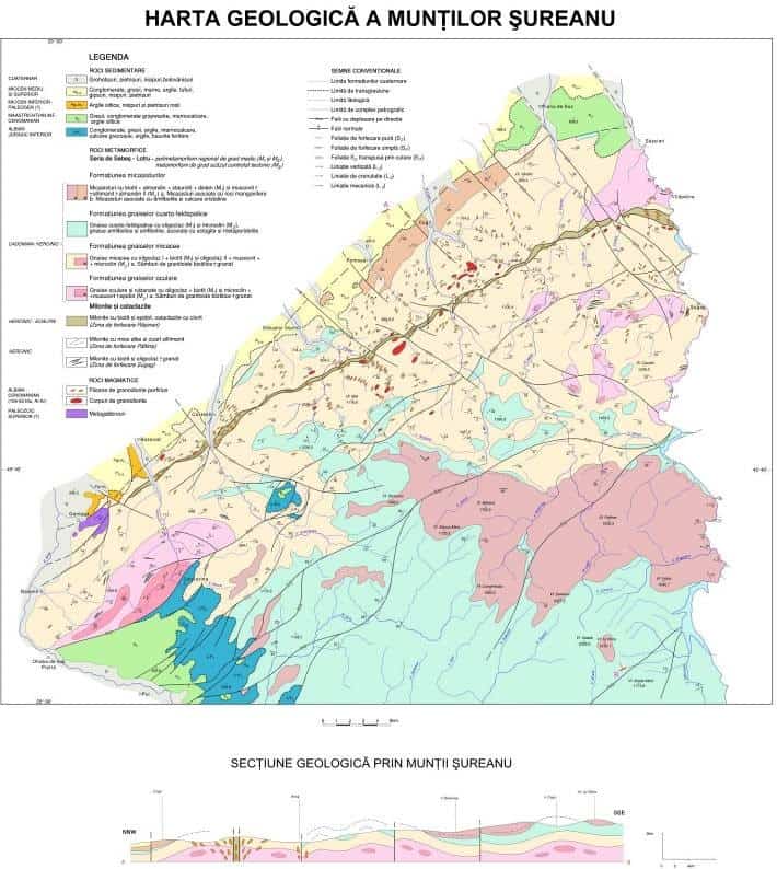
The augen gneiss complex consists of augen gneisses with local transitions to banded, planar-parallel foliated gneisses. Typically, the two gneiss types are zonally arranged around relict cores of biotitic granitoids, forming domal or lenticular structures enveloped by the micaceous gneisses of the overlying complex.
The mica-gneiss complex consists of gneisses with well-defined foliation and relatively high mica content, in which plagioclase is the predominant feldspar. In older geological literature, these gneisses were commonly described using the genetic term “paragneiss,” based on the premise that they were of sedimentary origin. Amphibolite intercalations are relatively frequent near the lower boundary of the complex and at the northern end of the massif.
The quartz-feldspar (microcline) gneiss complex consists primarily of granoblastic, mica-poor gneisses associated with amphibole gneisses and amphibolites. The rocks are weakly foliated and frequently exhibit massive, magmatic-type textures. This complex hosts the majority of the ultrabasic rock and eclogite lenses found in the Getic Crystalline basement, as well as some of the manganiferous rock lenses (in the upper section).
The mica-schist complex crops out with distinct characteristics in two areas: a broad one in the central part of the massif and a narrow one along its northern margin. The mica-schists in the central zone contain lenses of micaceous gneiss, amphibolite, eclogite, manganiferous rocks, and quartz-feldspar gneiss—the latter two occurring in the lower section. The mica-schists in the northern zone contain intercalations of micaceous gneiss, amphibolite, and crystalline limestone. The presence of manganiferous rock lenses and intercalations of amphibolite and crystalline limestone suggests a metapelitic origin for this complex, a conclusion also supported by the aluminous chemistry of the mica-schists.
To produce the soil thickness map (Fig. 5), we used data collected from 455 observation points located in the eastern and southern halves of the Şureanu Mountains. The profiles along which observations and measurements were made are described below:
Fig. 5 - Soil thickness map of the Șureanu Mountains – partial map
- Profile: Şureanu Peak – Brateş Ridge – Pârva Peak – Dobraia Peak – Comărnicelu Peak – Gruişoara Mare Peak, Dealul Negru Peak – Muncelul Dobraiei – Dobraia Ridge – Pătru Peak – Auşel Peak;
- Iezerul Şureanu Profile – Cârpa Peak – Negovanu Peak – Curmătura Şureanu – Auşel Peak – Clăbucet Peak;
- Profile: Muncelu Peak – Godeanu Peak – Steaua Mică Peak – Steaua Mare Peak;
- Profile: Negru Peak – Luncile Prigoanei;
- Profile: Izv. Râului Mic – Bătrâna Mountain – Șinca Peak – Mlăcile Ridge – Sipcea Peak;
- Profile: Dealul Țețu – Ivănuș Peak – Dealul Cucului – Dealul Bârsana – Tițiana Peak – Mărtinie Valley – Arți – La Vârtoape – Smida Peak – Miraș Valley;
- Profile: Măgura Hill – Țețu Hill – Cucului Hill – Tonii Valley – Loman – Săsciori – Mărtinie Valley – Bârsana – Teascului Hill – Crucii Hill – Păltinișului Hill;
- Profile: Pianu Stream – Arşiţei Hill – Mujeştilor Hill – Bardo Hill – Hălmului Hill – Cioarei Hill – Purcăreţi Hill – Strungari – Tonii Stream – Recii Stream – Pienelul Recii Stream;
- Route: Miraş Valley – Poiana Comanului – Balele Chalet – Prigoana Valley – Luncile Prigoanei – Oaşa Monastery – Oaşa Dam;
- Profile: Oaşa Lake contour road – Luncile Prigoanei;
- Sipcea Valley Profile – Răchita Peak – Comanului Hill – Preluca Valley – Poiana Groşilor – Molivişului Hill – Răchita Mare Hill;
- Preluca V Profile – Preluca Groşilor Peak – Răchita Peak – Bocşitura Peak – Gogele Peak – Dealul Popii – Bucuru – Sasu Valley;
- Untului Valley – Gropşoara Valley – Pârva Valley – Negovanu Peak – Boşorog Valley – Râul Mare Valley – Cujerele – Cărpa Ranger Station – Poarta Raiului – Luncile Prigoanei;
- Profile of the Prigoana–Prisaca forest road – Diudiu Valley – Costeasa Valley – Prigoana Valley;
- Profile V Gâlceag – forest road V. Gâlceag – V. Miraş;
- Profile V Râul Mare – V. Moliviş – V. Crestăturii – V. Răchiţii – Cugir – V. Călene – V. Sibişel – V. Râuşorul – Sibişel;
- Miraş Valley – Curmături – Tomnăticelul Hill – Căpâlna – Jidoştina – Tău Bistra – Prigoana Valley;
- Route Profile: Poarta Raiului – Vf. lui Pătru – Vf. Auşel – Taia Valley – Brateş Valley – Râul Mare Headwaters – Frumoasa Valley – Tărtărău Valley – Poiana Muierii – Obârşia Lotrului;
- Strei Valley Profile – Lomonească Valley – Rea Valley – Jigoroşiţa Valley – Jidgureasa Valley – Răchiţelei Valley – Porumbelul Mare Peak – Sasu Valley – Mare Valley;
- Streiului Valley – Pârâul Calului – Pârâul Rovina – Sasu Valley – Tiţianu Peak – Gruiu Clearing – Diţei Clearing – Botanilor Hill – Boului Hill – Galbena Valley;
- Taia Valley Profile – Popii Valley – Preoteasa Valley – Muncelul Dobraiei – Dobra Valley – Aușel Valley – Dobraia Valley;
- Profile V: Auşel Valley – Dobraia Valley – Clăbucet Valley – Răscoala Valley;
The measurements taken along these profiles were used to create a soil thickness map for the Șureanu Mountains—a partial map that allows for an assessment of the current situation and serves as a basis for future soil quality monitoring.
Works published in publications indexed in other international databases:
- Ghenciu Monica, Culescu Flori. Ion Popescu-Voitești. Works on paleogeography, Litua, 2023, vol. XXV, p. 443-447.
- Ghenciu Monica, Popescu Aurelian, Ion Daniel, Alexe Veronica.Copper mineralizations from Baia de Aramă. Historical and metallogenetical data, Oltenia Journal for Studies in Natural Sciences, 2023, vol. 39/II, p. 12-15.
- Culescu Flori, Ghenciu Monica. Pebbles with intracarpathian source area in the gravels from Cotmeana and Olteț piedmonts (Romania), Oltenia Journal for Studies in Natural Sciences, 2023, vol. 39/I, p. 39-43
- Stelea Ion, Ghenciu Monica, Culescu Flori. Cordierite and sillimanite in the central and eastern South Carpathians, Oltenia Journal for Studies in Natural Sciences, vol. 39/II, p. 7-11.
- Culescu Flori, Ghenciu Monica, Vijdea Anca, Stelea Ion,Tătaru Adrian. Evaluation of the impact of anthropic activities on soils in Şureanu Mountains, România. Preliminary data, Litua, 2024, vol. XXVI, p. 491-497
- Ghenciu Monica , Stelea Ion. Tectonics and seismicity of Northwestern Oltenia, Litua, 2024, vol. XXVI, p. 499-505
- Stelea Ion,Comments on old geological maps regarding Oltenia (1876-1940), Litua, 2024, vol. XXVI, p. 507-513
- Stelea Ion. Active tectonic processes on the territory of Romania, Litua, 2024, vol. XXVI, p. 515-520
- Stelea Ion. Structural and lithological relics in the Getic Crystalline of the South Carpathian, Oltenia Journal for Studies in Natural Sciences, 2024, vol. XL/I, p. 28-31
- Culescu Flori, Ghenciu Monica. The area distribution of boulders in the gravels of the eastern Getic Piedmont, Oltenia Journal for Studies in Natural Sciences, 2024, vol. XL/I, p. 25-27
- Ghenciu Monica, Stelea Ion. Old geological maps regarding Muntenia (1889-1943), Oltenia Journal for Studies in Natural Sciences, 2024, vol. XL/I, p. 32-34
- Stelea Ion. Regional shear zones in the metamorphic basement, Marisia – Natural Sciences, 2024, vol. IV, p. 75-78
- Ghenciu Monica. Marcian Bleahu – contributions to the construction of the geological map of Romania, Marisia – Natural Sciences, 2025, vol. IV, p. 79-81